World’s oldest person dies in New York at age 116

The death of 116-year-old Susannah Mushatt Jones in New York City on Thursday leaves just one person on Earth who was alive in the 1800s.

Born about a month before 1900 began and when England’s Queen Victoria was still on the throne, Emma Morano is now the oldest living person. Incredibly, she still lives on her own in northern Italy.

On Friday, she was happy to hear the title had passed to her, one of her relatives told London’s Daily Telegraph newspaper. “She was told this morning and she said ‘My word, I’m as old as the hills,’ but she was very pleased,” Rosi Santoni said.

Morano was not able to come to the phone, the Telegraph reported – she is almost completely deaf. When the Telegraph reporter called she was eating a lunch of semolina with a boiled egg. She eats a raw egg each day, ever since a doctor’s recommendation when she was diagnosed with anemia at the age of 20.

Here is her story:

Name: Emma Morano
Country of residence: Italy
Birthday: Nov. 29, 1899

Morano was the first of eight children, all of whom have since died. One sister lived to be 102. In 1926, she married and in 1937 her only child was born, but died at a few months old. In 1938, she separated from her husband, Giovanni Martinuzzi, but never divorced. Until 1954, she was a worker at a jute factory in her town before working in the kitchen of a boarding school. She retired at 75.

When asked about the secret of her longevity by the La Stampa newspaper in 2015, she first mentioned her daily glass of homemade brandy.

But Morano mostly cites her eating habits for helped her live so long. “For breakfast I eat biscuits with milk or water,” she said. “Then during the day I eat two eggs — one raw and one cooked — just like the doctor recommended when I was 20 years old. For lunch I’ll eat pasta and minced meat then for dinner, I’ll have just a glass of milk.”

Sleep is another important factor in her longevity, she told the newspaper. Morano goes to bed before 7 every night and wakes up before 6 a.m.

Her physician, Dr. Carlo Bava, is convinced there’s a genetic component as well.

“From a strictly medical and scientific point of view, she can be considered a phenomenon,” he told the Associated Press, noting that Morano takes no medication and has been in stable, good health for years.

Italy is known for its centenarians — many of whom live in Sardinia — and gerontologists at the University of Milan are studying Morano, along with a handful of Italians over age 105, to try to figure out why they live so long.

“Emma seems to go against everything that could be considered the guidelines for correct nutrition: She has always eaten what she wants, with a diet that is absolutely repetitive,” Bava said. “For years, she has eaten the same thing every day, not much vegetables or fruit. But she’s gotten this far.”

When the AP visited in 2015, Morano was in feisty spirits, displaying the sharp wit and fine voice that she says used to stop men in their tracks.

“I sang in my house, and people on the road stopped to hear me singing. And then they had to run because they were late and should go to work,” she recalled, before breaking into a round of the 1930s Italian love song Parlami d’amore Mariu.

“Ahh, I don’t have my voice anymore,” she lamented at the end.

But even though her movements now are limited, according to the AP — she gets out of bed and into her armchair and back again, her eyesight is bad and hearing weak — she does seem to walk around at night.

“Her niece and I leave some biscuits and chocolates out at night in the kitchen. And in the morning they’re gone, which means someone has gotten up during the night and eaten them,” Bava said.

On her 116th birthday last year Morano received a congratulatory telegram from Sergio Mattarella, the president of Italy, according to the Telegraph, and a signed parchment of blessing from Pope Francis, which is now framed and hangs on the wall of her apartment.

http://www.usatoday.com/story/news/world/2016/05/13/shes-only-person-left-born-1800s/84321322/

French teenager broadcasts her suicide on Periscope

by Erin Zaleski

A young French woman broadcast her last moments in a haunting livestream video.

More than 1,000 people are believed to have watched the young woman kill herself.

They watched her calmly discuss her decision to die, just as they watched her slip on her sneakers before heading to a nearby station and throwing herself in front of an oncoming suburban RER C train.

No one watching was able to approach the platform, or yell for her to stop, or to do anything else that may have prevented her from carrying out her desperate act, because no one could. The hundreds of people who witnessed her last moments watched the drama unfold behind their phone screens.

At the Egly train station south of Paris on Tuesday, a French teenager broadcast her suicide on Periscope, a smartphone app that allows users to stream live videos. The video has reportedly been removed from Periscope, but footage of the minutes leading up to her death has been posted on YouTube.

While suicide, and even public suicide, is nothing new, the age of social media makes such acts of despair accessible in a way they have never been previously. Indeed, Tuesday’s tragedy near Paris is not the first time a young person has broadcast a suicide on social media. In 2010, a 21-year-old Swedish man hanged himself on a live webcam broadcast. And a young woman in Shanghai documented the events leading up to her suicide on Instagram in 2014, uploading a series of disturbing images, including one in which her legs are dangling out of the window of a high-rise apartment.

“I will haunt you day and night after I’m dead,” she reportedly posted on the photo-sharing app in a message to her ex-boyfriend before jumping to her death.

In its guidelines, Periscope, which is owned by Twitter, prohibits what it deems “explicitly graphic content or media that is intended to incite violent, illegal or dangerous activities.” However, with some 10 million active users, monitoring every account 24/7 would be daunting, if not impossible.

“Why do you say you love me, you don’t even know me?” asks the pretty young woman seated on a red couch in her apartment and facing the camera. She is pale with long brown hair and piercings, one in her left nostril and two just beneath her lower lip. A prospective suitor has messaged her, but she calmly and firmly rebuffs his advances.

“Yes, I am single, but I am not looking for that. Really.”

She rolls a cigarette before continuing.

“What is about to happen is very shocking, so those who are underage should leave.”

She takes a long drag and continues to field questions from users. She tells them that she is 19 and works at a retirement home. Her determined, unemotional demeanor is a bit unsettling to watch. As is the way she calmly answers questions, sometimes even cracking a smile or unleashing a soft giggle.

“Why are you asking me who I am?” she asks with a chuckle before taking another drag. “I am no one.”

At one point she stops speaking and continues to smoke while scrolling through messages other Periscope users are sending her—mostly lame pick-up lines and other typical online inanities. Footage of her final act has been replaced with a black screen, but the faint voices of emergency personnel can be heard on the audio track, and messages from fellow users shift from playful banter to disbelief to concern.

“Stop messing around,” one of them reads.

“Where did she go? Call the cops!” reads another.

Indeed, it was a fellow Periscope user who alerted emergency services, but by the time they arrived at the station yesterday afternoon it was too late. French police have reportedly launched an investigation into her death.

Before she died, the young French woman reportedly claimed to be a victim of a sexual assault and named her alleged attacker. Whether it was the trauma of rape or another reason that drove her to violently end her life is not known. More unnerving is her decision to broadcast her death to hundreds of strangers. It’s not clear whether it’s a cry for help, since in the video she refuses to divulge any personal details, including her name and location. Had she wanted to feel less alone? Was she seeking empathy? Or in today’s digital world, where we joke that an event never really happened unless it’s posted, tweeted, or streamed, was she merely seeking to document, and thus, validate, the last moments of her life?

“What I want to make clear is that I am not doing this for the hype, but to send a message, to open minds,” she explains in the video.

The precise nature of the message she was hoping to send may never be understood. Instead, we are left a troubling glimpse of a young woman in pain, whom no one could help in time.

http://www.thedailybeast.com/articles/2016/05/11/french-teen-periscopes-her-suicide.html

Robot outperforms highly-skilled human surgeons on pig GI surgery

A robot surgeon has been taught to perform a delicate procedure—stitching soft tissue together with a needle and thread—more precisely and reliably than even the best human doctor.

The Smart Tissue Autonomous Robot (STAR), developed by researchers at Children’s National Health System in Washington, D.C., uses an advanced 3-D imaging system and very precise force sensing to apply stitches with submillimeter precision. The system was designed to copy state-of-the art surgical practice, but in tests involving living pigs, it proved capable of outperforming its teachers.

Currently, most surgical robots are controlled remotely, and no automated surgical system has been used to manipulate soft tissue. So the work, described today in the journal Science Translational Medicine, shows the potential for automated surgical tools to improve patient outcomes. More than 45 million soft-tissue surgeries are performed in the U.S. each year. Examples include hernia operations and repairs of torn muscles.

“Imagine that you need a surgery, or your loved one needs a surgery,” says Peter Kim, a pediatric surgeon at Children’s National, who led the work. “Wouldn’t it be critical to have the best surgeon and the best surgical techniques available?”

Kim does not see the technology replacing human surgeons. He explains that a surgeon still oversees the robot’s work and will take over in an emergency, such as unexpected bleeding.

“Even though we take pride in our craft of doing surgical procedures, to have a machine or tool that works with us in ensuring better outcome safety and reducing complications—[there] would be a tremendous benefit,” Kim says. The new system is an impressive example of a robot performing delicate manipulation. If robots can master human-level dexterity, they could conceivably take on many more tasks and jobs.

STAR consists of an industrial robot equipped with several custom-made components. The researchers developed a force-sensitive device for suturing and, most important, a near-infrared camera capable of imaging soft tissue in detail when fluorescent markers are injected.

“It’s an important result,” says Ken Goldberg, a professor at UC Berkeley who is also developing robotic surgical systems. “The innovation in 3-D sensing is particularly interesting.”

Goldberg’s team is developed surgical robots that could be more flexible than STAR because instead of being manually programmed, they can learn automatically by observing expert surgeons. “Copying the skill of experts is really the next step here,” he says.

https://www.technologyreview.com/s/601378/nimble-fingered-robot-outperforms-the-best-human-surgeons/

Thanks to Kebmodee for bringing this to the It’s Interesting community.

15 year old William Gadoury draws a link between the location of Mayan cities and the civilization’s major constellations to discover a Mayan city in Central America using Google Earth

A 15-year-old boy believes he has discovered a forgotten Mayan city using satellite photos and Mayan astronomy.

William Gadoury, from Quebec, came up with the theory that the Maya civilization chose the location of its towns and cities according to its star constellations.

He found Mayan cities lined up exactly with stars in the civilization’s major constellations.

Studying the star map further, he discovered one city was missing from a constellation of three stars.

Using satellite images provided by the Canadian Space Agency and then mapped on to Google Earth, he discovered the city where the third star of the constellation suggested it would be.

William has named the yet-to-be explored city in the Yucatan jungle K’aak Chi, or Mouth of Fire.

Daniel De Lisle, from the Canadian Space Agency, said the area had been difficult to study because of its dense vegetation.

However, satellite scans of the area found linear features which “stuck out”.

“There are linear features that would suggest there is something underneath that big canopy,” he told The Independent.

“There are enough items to suggest it could be a man made structure.”

Doctor Armand La Rocque, from the University of New Brunswick, said one image showed a street network and a large square which could possibly be a pyramid.

He told The Independent: “A square is not natural, it is mostly artificial and can hardly be attributed to natural phenomena.

“If we add these together, we have a lot of indication there might be a Mayan city in the area.”

Dr La Rocque said William’s discovery could lead archaeologists to find other Mayan cities using similar techniques.

William’s discovery will be published in a scientific journal and he will present his findings at Brazil’s International Science fair in 2017.

http://www.independent.co.uk/news/world/americas/forgotten-mayan-city-discovered-in-central-america-by-15-year-old-a7021291.html

Thanks to Kebmodee for bringing this to the attention of the It’s Interesting community.

Aokigahara: Japan’s Suicide Forest

by Kristy Puchko

Northwest of the majestic Mount Fuji is the sprawling 13.5 square miles of Aokigahara, a forest so thick with foliage that it’s known as the Sea of Trees. But it’s the Japanese landmark’s horrific history that made the woods a fitting location for the spooky horror film The Forest. Untold visitors have chosen this place, notoriously called The Suicide Forest, as the setting for their final moments, walking in with no intention of ever walking back out. Here are a few of the terrible truths and scary stories that forged Aokigahara’s morbid reputation.

1. AOKIGAHARA IS ONE OF THE MOST POPULAR SUICIDE DESTINATIONS IN THE WORLD.

Statistics on Aokigahara’s suicide rates vary, in part because the forest is so lush that some corpses can go undiscovered for years or might be forever lost. However, some estimates claim as many as 100 people a year have successfully killed themselves there.


2. JAPAN HAS A LONG TRADITION OF SUICIDE.

Self-inflicted death doesn’t carry the same stigma in this nation as it does in others. Seppuku—a samurai’s ritual suicide thought to be honorable—dates back to Japan’s feudal era. And while the practice is no longer the norm, it has left a mark. “Vestiges of the seppuku culture can be seen today in the way suicide is viewed as a way of taking responsibility,” said Yoshinori Cho, author of Why do People Commit Suicide? and director of the psychiatry department at Teikyo University in Kawasaki, Kanagawa.

3. JAPAN HAS ONE OF THE HIGHEST SUICIDE RATES IN THE WORLD.

The global financial crisis of 2008 made matters worse, resulting in 2,645 recorded suicides in January 2009, a 15 percent increase from the previous year. The numbers reached their peak in March, the end of Japan’s financial year. In 2011, the executive director of a suicide prevention hotline told Japan Times, “Callers most frequently cite mental health and family problems as the reason for contemplating suicide. But behind that are other issues, such as financial problems or losing their job.”

4. SUICIDE PREVENTION ATTEMPTS INCLUDE SURVEILLANCE AND POSITIVE POSTS.

Because of the high suicide rate, Japan’s government enacted a plan of action that aims to reduce such rates by 20 percent within the next seven years. Part of these measures included posting security cameras at the entrance of the Suicide Forest and increasing patrols. Suicide counselors and police have also posted signs on various paths throughout the forest that offer messages like “Think carefully about your children, your family” and “Your life is a precious gift from your parents.”

5. IT’S NATURALLY EERIE.

Bad reputation aside, this is no place for a leisurely stroll. The forest’s trees organically twist and turn, their roots winding across the forest floor in treacherous threads. Because of its location at the base of a mountain, the ground is uneven, rocky, and perforated with hundreds of caves. But more jarring than its tricky terrain is the feeling of isolation created from the stillness; the trees are too tightly packed for winds to whip through and the wildlife is sparse. One visitor described the silence as “chasms of emptiness.” She added, “I cannot emphasize enough the absence of sound. My breath sounded like a roar.”

6. DEATH BY HANGING IS THE MOST POPULAR METHOD OF SUICIDE AMONG THE SEA OF TREES.

The second is said to be poisoning, often by drug overdose.

7. A NOVEL POPULARIZED THIS DARK TRADITION. . .

In 1960, Japanese writer Seichō Matsumoto released the tragic novel Kuroi Jukai, in which a heartbroken lover retreats to the Sea of Trees to end her life. This romantic imagery has proved a seminal and sinister influence on Japanese culture. Also, looped into this lore: The Complete Suicide Manual, which dubs Aokigahara “the perfect place to die.” The book has been found among the abandoned possessions of various Suicide Forest visitors.

8. BUT IT WAS NOT THE START OF THE FOREST’S DARK LEGACY.

Ubasute is a brutal form of euthanasia that translates roughly to “abandoning the old woman.” An uncommon practice—only resorted to in desperate times of famine—where a family would lessen the amount of mouths to feed by leading an elderly relative to a mountain or similarly remote and rough environment to die, not by means of suicide but by dehydration, starvation, or exposure. Some insist this was not a real occurrence, but rather grim folklore. Regardless, stories of the Sea of Trees being a site for such abandonment have long been a part of its mythos.

9. THE SUICIDE FOREST MAY BE HAUNTED.

Some believe the ghosts—or yurei—of those abandoned by ubasute and the mournful spirits of the suicidal linger in the woods. Folklore claims they are vengeful, dedicated to tormenting visitors and luring those that are sad and lost off the path.

10. ANNUAL SEARCHES HAVE BEEN HELD THERE SINCE 1970.

There are volunteers who do patrol the area, making interventional efforts. However, these annual endeavors are not intended to rescue people, but to recover their remains. Police and volunteers trek through the Sea of Trees to bring bodies back to civilization for a proper burial. In recent years, the Japanese government has declined to release the numbers of corpses recovered from these gruesome searches. But in the early 2000s, 70 to 100 were uncovered each year.

11. BRINGING A TENT INTO THE FOREST SUGGESTS DOUBT.

Camping is allowed in the area but visitors who bring a tent with them are believed to be undecided on their suicide attempt. Some will camp for days, debating their fates. People on prevention patrol will gently speak with such campers, entreating them to leave the forest.

12. THE SUICIDE FOREST IS SO THICK THAT SOME VISITORS USE TAPE TO AVOID GETTING LOST.

Volunteers who search the area for bodies and those considering suicide typically mark their way with plastic ribbon that they’ll loop around trees in this leafy labyrinth. Otherwise, one could easily lose their bearings after leaving the path and become fatally lost.

13. YOU MAY NOT BE ABLE TO CALL FOR HELP.

Rich with magnetic iron, the soil of the Suicide Forest plays havoc on cellphone service, GPS systems, and even compasses. This is why tape can be so crucial. But some believe this feature is proof of demons in the dark.

14. NOT EVERYONE WHO GOES THERE HAS DEATH ON THEIR AGENDA.

Locals lament that this natural wonder is known first and foremost for its lethal allure. Still, tourists can take in gorgeous views of Mount Fuji and visit highlights like the distinctive lava plateau, 300-year-old trees, and the enchanting Narusawa Ice Cave.

15. GOING OFF THE PATH CAN LEAD TO GHASTLY DISCOVERIES.

The Internet is littered with disturbing images from the Suicide Forest, from abandoned personal effects snared in the undergrowth to human bones and even more grisly remains strewn across the forest floor or dangling from branches. So if you dare to venture into this forbidding forest, do as the signs suggest and stay on the path.

http://mentalfloss.com/article/73288/15-eerie-things-about-japans-suicide-forest

Obama Signs Legislation Designating Bison National Mammal

The bison has become the official national mammal of the United States under legislation signed into law by President Barack Obama on Monday.

Lawmakers spearheading the effort say the once nearly extinct icon deserves the elevated stature because of its economic and cultural significance in the nation’s history.

Millions of bison once roamed the Great Plains. About 500,000 now live in the U.S. but most of those have been cross-bred with cattle, and are semi-domesticated. About 30,000 wild bison roam the country, with the largest population in Yellowstone National Park.

Supporters of the legislation say they believe the recognition will elevate the stature of the bison to that of the bald eagle, long the national emblem, and bring greater attention to ongoing recovery efforts of the species.

“I hope that in my lifetime, thanks to a broad coalition of ranchers, wildlife advocates and tribal nations, we will see bison return to the prominent place they once occupied in our nation’s shortgrass prairies,” said Democratic Sen. Martin Heinrich of New Mexico, who worked with Republican Sen. John Hoeven of North Dakota to pass the Senate version of the legislation.

http://www.nbcnews.com/news/us-news/obama-signs-legislation-designating-bison-national-mammal-n570801

Creator of Dilbert explains why he thinks Trump will win the U.S. presidency in a landslide

By Michael Cavna

SCOTT ADAMS remembers just how the game turned. He was young and improving at chess, but the masterful kid across the board would outmaneuver Adams till the game seemed a runaway. Now, this kid didn’t want to just beat Adams; he wanted to embarrass him. “So after he’d picked away three-fourths of my pieces and I was discouraged,” Adams recounts, “he would offer to turn the board around and play with my pieces.” And then effectively “win” again.

On those occasions, Scott Adams, the creator of “Dilbert,” got insight into the type of personality that loves not only the challenge of game strategy, but also the thrill of overwhelming the competition. It is the sport of meticulously plotted domination.

And that is part of why Adams believes Donald Trump will win the presidency. In a landslide.

[‘The Simpsons’ predicted a Trump presidency 16 years ago. The writer illuminates the reasons]

Adams, in other words, believes that Trump himself has turned the campaign game around. On the stump, the real-estate mogul is not running on the knowledge of his numbers or the dissection of the data. He is running on our emotions, Adams says, and sly appeals to our own human irrationality. Since last August, in fact, when many were calling Trump’s entry a clown candidacy, the “Dilbert” cartoonist was already declaring The Donald a master in the powers of persuasion who would undoubtedly rise in the polls. And last week, Adams began blogging about how Trump can rhetorically dismantle Clinton’s candidacy next.

Adams, mind you, is not endorsing Trump or supporting his politics. (“I don’t think my political views align with anybody,” he tells The Post’s Comic Riffs, “not even another human being.”) And he is not saying that Trump would be the best president. What the Bay Area-based cartoonist recognizes, he says, is the careful art behind Trump’s rhetorical techniques. And The Donald, he says, is playing his competitors like a fiddle — before beating them like a drum.

Most simply put: Adams believes Trump will win because he’s “a master persuader.”

The Manhattan mogul is so deft at the powers of persuasion, Adams believes, that the candidate could have run as a Democrat and, by picking different hot-button issues, still won this presidency. In other words: Trump is such a master linguistic strategist that he could have turned the political chessboard around and still embarrassed the field.

Adams does not claim to be a trained political analyst. His stated credentials in this arena, says Adams — who holds an MBA from UC Berkeley — largely involve being a certified hypnotist and, as a writer and business author, an eternal student in the techniques of persuasive rhetoric. (His self-help memoir is titled “How to Fail at Almost Everything and Still Win Big: Kind of the Story of My Life.”)

“The most important thing when you study hypnosis is that you learn that humans are irrational,” Adams tells Comic Riffs. “Until you understand that, hypnosis is hard to do. … For me, it was this great awakening to understand that humans are deeply irrational, and it’s probably the greatest influence on me in terms of my writing.”

“This was a trick I learned from Bil Keane,” the late creator of “Family Circus,” Adams tells Comic Riffs. “He basically taught me to stop writing for myself, which I realized I had been doing — writing a comic that I wanted to read.”

So Adams pivoted to write more about the workplace, and the budding “Dilbert” in the early ’90s became “about this huge part of people’s lives that was invisible to the rest of the world and about suffering in a hundred different ways.”

“By simply mentioning that world,” Adams says, the comic connected with readers “on an emotional level.”

And isn’t that essentially, in turn, what Trump is doing? He is acknowledging the suffering of some, Adams says, and then appealing emotionally to that.

And he bolsters that approach, Adams says, by “exploiting the business model” like an entrepreneur. In this model, which “the news industry doesn’t have the ability to change … the media doesn’t really have the option of ignoring the most interesting story,” says Adams, contending that Trump “can always be the most interesting story if he has nothing to fear and nothing to lose.”

Having nothing to lose essentially then increases his chance of winning, because it opens up his field of rhetorical play. “Psychology is the only necessary skill for running for president,” writes Adams, adding: “Trump knows psychology.”
Within that context, here is what Candidate Trump is doing to win campaign hearts and minds, according to Scott Adams:

1. Trump knows people are basically irrational.

“If you see voters as rational you’ll be a terrible politician,” Adams writes on his blog. “People are not wired to be rational. Our brains simply evolved to keep us alive. Brains did not evolve to give us truth. Brains merely give us movies in our minds that keeps us sane and motivated. But none of it is rational or true, except maybe sometimes by coincidence.”

2. Knowing that people are irrational, Trump aims to appeal on an emotional level.

“The evidence is that Trump completely ignores reality and rational thinking in favor of emotional appeal,” Adams writes. “Sure, much of what Trump says makes sense to his supporters, but I assure you that is coincidence. Trump says whatever gets him the result he wants. He understands humans as 90-percent irrational and acts accordingly.”

Adams adds: “People vote based on emotion. Period.”

3. By running on emotion, facts don’t matter.

“While his opponents are losing sleep trying to memorize the names of foreign leaders – in case someone asks – Trump knows that is a waste of time … ,” Adams writes. “There are plenty of important facts Trump does not know. But the reason he doesn’t know those facts is – in part – because he knows facts don’t matter. They never have and they never will. So he ignores them.

“Right in front of you.”

And stating numbers that might not quite be facts nevertheless can anchor those numbers, and facts, in your mind.

4. If facts don’t matter, you can’t really be “wrong.”

Trump “doesn’t apologize or correct himself. If you are not trained in persuasion, Trump looks stupid, evil, and maybe crazy,” Adams writes. “If you understand persuasion, Trump is pitch-perfect most of the time. He ignores unnecessary rational thought and objective data and incessantly hammers on what matters (emotio“Did Trump’s involvement in the birther thing confuse you?” Adams goes on to ask. “Were you wondering how Trump could believe Obama was not a citizen? The answer is that Trump never believed anything about Obama’s place of birth. The facts were irrelevant, so he ignored them while finding a place in the hearts of conservatives. For later.

“This is later. He plans ahead.”

5. With fewer facts in play, it’s easier to bend reality.

Steve Jobs famously aimed to create “reality distortion fields” to meet his needs and achieve his ends. Trump employs similar techniques, and apparently can be similarly thin-skinned when his “reality” is challenged. “The Master Persuader will warp reality until he gets what he wants,” writes Adams, noting that Trump is “halfway done” already.

(Among the persuasive techniques that Trump uses to help bend reality, Adams says, are repetition of phrases; “thinking past the sale” so the initial part of his premise is stated as a given; and knowing the appeal of the simplest answer, which relates to the concept of Occam’s razor.)

6. To bend reality, Trump is a master of identity politics — and identity is the strongest persuader.

One way to achieve this is by deploying “linguistic kill shots” that land true, and alter perception through two ways.“Do you think it is a coincidence that Trump called Megyn Kelly a bimbo and then she got a non-bimbo haircut that is … well, Trumpian?” Adams writes. “It doesn’t look like a coincidence to this trained persuader.”

“The best Trump linguistic kill shots,” Adams writes,”have the following qualities: 1. Fresh word that is not generally used in politics; 2. Relates to the physicality of the subject (so you are always reminded).”

Writes Adams: “Identity is always the strongest level of persuasion. The only way to beat it is with dirty tricks or a stronger identity play. … [And] Trump is well on his way to owning the identities of American, Alpha Males, and Women Who Like Alpha Males. Clinton is well on her way to owning the identities of angry women, beta males, immigrants, and disenfranchised minorities.

“If this were poker, which hand looks stronger to you for a national election?”

Death by GPS


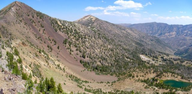
The Jarbidge Mountains of Nevada, where the Chretiens got stranded.

One early morning in March 2011, Albert Chretien and his wife, Rita, loaded their Chevrolet Astro van and drove away from their home in Penticton, British Columbia. Their destination was Las Vegas, where Albert planned to attend a trade show. They crossed the border and, somewhere in northern Oregon, they picked up Interstate 84.

The straightest route would be to take I-84 to Twin Falls, Idaho, near the Nevada border, and then follow US Route 93 all the way to Vegas. Although US 93 would take them through Jackpot, Nevada, the town near the Idaho state line where they planned to spend the first night, they looked at a roadmap and decided to exit I-84 before that junction. They would choose a scenic road less traveled, Idaho State Highway 51, which heads due south away from the I-84 corridor, crossing the border several miles to the west. The Chretiens figured there had to be a turnoff from Idaho 51 that would lead them east to US 93.

Albert and Rita had known each other since high school. During their thirty-eight years of marriage, they had rarely been apart. They even worked together, managing their own small excavation business. A few days before the trip, Albert had purchased a Magellan GPS unit for the van. They had not yet asked it for directions, but their plan wasn’t panning out. As the day went on and the shadows grew longer, they were not finding an eastward passage. They decided it was time to consult the Magellan. Checking their roadmap, they determined the nearest town was Mountain City, Nevada, so they entered it as the destination into their GPS unit. The directions led them onto a small dirt road near an Idaho ghost town and eventually to a confusing three-way crossroads. They chose the one that seemed to point in the direction they wanted to go. And here their troubles began.

If Albert had been navigating the route in the daytime, he might have noticed that it was taking them through the high desert as it rose toward shimmering snowy peaks in the distance. In the dark, the changes were so subtle that they barely registered. And besides, he was on a road—“a pretty good road,” the Elko County sheriff would later say, that “slowly goes bad.” Through the night, it carried them higher into the Jarbidge Mountains, deeper into the backcountry. The road twisted, dipped, rose again, skirting canyons walled with sagebrush. It was the kind of terrain for which the Chretiens’ van was not designed.

Several days passed before their family and friends realized that Albert and Rita had never arrived at the trade show. The couple had not informed anyone of their detour, so nobody knew where to look for them. The manhunt involved police agencies in four states, scouring 3,000 miles of highway, with the most intense efforts in eastern Oregon, where they had used a credit card in a convenience store. On April 8, just shy of three weeks since Albert Chretien left Highway 51, authorities announced they were scaling back search and rescue efforts, a tacit admission that wherever the Chretiens had gone, it was too late to find them.

What happened to the Chretiens is so common in some places that it has a name. The park rangers at Death Valley National Park in California call it “death by GPS.” It describes what happens when your GPS fails you, not by being wrong, exactly, but often by being too right. It does such a good job of computing the most direct route from Point A to Point B that it takes you down roads which barely exist, or were used at one time and abandoned, or are not suitable for your car, or which require all kinds of local knowledge that would make you aware that making that turn is bad news.

Death Valley’s vast arid landscape and temperature extremes make it a particularly dangerous place to rely on GPS. In the summer of 2009, Alicia Sanchez, a twenty-eight-year-old nurse, was driving through the park with her six-year-old son, Carlos, when her GPS directed her onto a vaguely defined road that she followed for 20 miles, unaware that it had no outlet. A week later, a ranger discovered Sanchez’s Jeep, buried in sand up to its axles, with sos spelled out in medical tape on the windshield. “She came running toward me and collapsed in my arms,” the ranger wrote in a report. “Her lips were very dry and chapped with bleeding blisters and her tongue appeared to be swollen with very little saliva formation. I walked over to the Jeep and looked inside. I saw a boy slumped in the front seat with obvious signs of death.” Mother and son had wandered over ten miles of desert in search of water, and had resorted to drinking their urine. They had tried to share a Pop-Tart a few days earlier, but their mouths were too dry to swallow. As he lay dying, Carlos grew delirious, telling his mother he was “speaking to my grandfather in heaven.”

Most death-by-GPS incidents do not involve actual deaths—or even serious injuries. They are accidents or accidental journeys brought about by an uncritical acceptance of turn-by-turn commands: the Japanese tourists in Australia who drove their car into the ocean while attempting to reach North Stradbroke Island from the mainland; the man who drove his BMW down a narrow path in a village in Yorkshire, England, and nearly over a cliff; the woman in Bellevue, Washington, who drove her car into a lake that their GPS said was a road; the Swedish couple who asked GPS to guide them to the Mediterranean island of Capri, but instead arrived at the Italian industrial town of Carpi; the elderly woman in Belgium who tried to use GPS to guide her to her home, 90 miles away, but instead drove hundreds of miles to Zagreb, only realizing her mistake when she noticed the street signs were in Croatian.

These types of mishaps often elicit sheer bafflement. The local Italian tourist official noted that although “Capri is an island,” the unfortunate Swedes “did not even wonder why they didn’t cross any bridge or take any boat;” the first responders in Bellevue were amazed that the women “wouldn’t question driving into a puddle that doesn’t seem to end.” For their part, the victims often couch their experiences in language that attributes to GPS a peculiar sort of agency. GPS “told us we could drive down there,” one of the Japanese tourists explained. “It kept saying it would navigate us a road.” The BMW driver echoed these words, almost verbatim: “It kept insisting the path was a road.”

Something is happening to us. Anyone who has driven a car through an unfamiliar place can attest to how easy it is to let GPS do all the work. We have come to depend on GPS, a technology that, in theory, makes it impossible to get lost. Not only are we still getting lost, we may actually be losing a part of ourselves.

The modern era of GPS car navigation began after Operation Desert Storm in 1990, and no GPS startup exploited its potential better than a Kansas City-area company called Garmin. Gary Burrell and Min Kao were engineers at AlliedSignal helping to develop a GPS receiver. (A prototype was on board the Rutan 76 Voyager, the record-setting aircraft that in 1986 became the first to circumnavigate the world with no stops or refueling.) After the project was discontinued, Burrell and Kao formed a new firm in 1989, its name a portmanteau of their given names.

Garmin was able to design components that made the most of limited processing power, especially in the acquisition of satellite signals. Even at the end of the nineties, GPS devices designed for cars required the user to tediously download maps. Over the next few years, map data made directions more accurate, better processors made it easier and quicker for algorithms to compute turn-by-turn directions, and memory improvements finally put all the maps in the box. Garmin’s C550 receivers, which hit the market in 2006, achieved full functionality. “Once solid-state memory had enough density to hold the entire country out of the box, that’s when the market really took off,” says Jay Dee Krull, one of Garmin’s earliest hires.

By 2006, Garmin controlled 60 percent of the US market for navigation equipment. Americans bought five million Garmin GPS receivers that year, as the company posted $1.68 billion in sales, a 64 percent increase from 2005. Fully half of the company’s revenue came from car GPS units, with sales in that segment growing at an astounding 140 percent annually.

As Garmin enjoyed spectacular growth, the popularity of GPS navigation led to renewed interest in how these devices were affecting the behavior of users. But instead of just investigating navigation systems’ design and effectiveness, some experts confronted the question of whether these new navigation systems might be weakening our cognitive map. Some of the widely praised attributes of navigation devices, especially their ability to present information in smoothly filtered ways that removed us from the bother of map-reading, came under closer scrutiny.
A 2006 German study, conducted by a group of psychologists and artificial intelligence experts, tested the hypothesis that users of a navigation system will remember less about an environment than those who use a map. Participants in the experiment walked a predetermined route through the zoo in the town of Saarbrücken carrying handheld computers connected by Bluetooth to a computer carried by an experimenter who followed several meters behind. He transmitted directions to the next segment of the route, beginning with a photo of the subject’s current location. In addition to the directions, one group of subjects also received visual cues, such as a map and red line that appeared on the photo; others received only verbal instructions; and a third group received a combination of verbal and visual cues. A control group walked the route guided only by a crude map that showed the route with no landmarks, along with the same photos shown to the test subjects at the start of each segment.

Later, all participants were given a two-part test to gauge how well they remembered the route. They were asked to recall what directions they had taken—at what points they had turned left, right, and so on. The second part tested what the researchers called survey knowledge: “the spatial relationships between locations.” The participants were shown thumbnail pictures of the intersections, and instructed to place them on a road map of the zoo. The researchers were essentially testing participants’ ability to construct a cognitive strip map and a cognitive comprehensive map.

The data revealed a couple of interesting insights. First, while it seems obvious why map users would have better overall knowledge of the area they walked, why would they also have a better memory of the route itself? The researchers reasoned that the map users had to engage in more active learning, having to match the photos they were given of the route with the markings on the map. The researchers had predicted—wrongly, as it turned out—that the two test groups who received visual aids that provided spatial context would outscore the verbal-only group in the survey knowledge test. Instead, they concluded that because this information was not required for the act of wayfinding, the subjects were not forced to actively process it.

A similar study, conducted in Japan and published in 2008, involved actual GPS devices. Three groups of walkers were studied as they navigated routes in the city of Kashiwa. One group learned the route from direct experience, shown it by a guide who took them from start to finish, and then back via a circuitous route; the subjects were then instructed to walk from start to finish again, with no assistance. Another group was given GPS devices, with the complete route highlighted on the screen, while another was given a paper map with the beginning and end points marked, but no highlighted route. The results showed the GPS users exhibiting the weakest wayfinding acumen. They traveled at a slower speed and made more stops to reorient themselves than the walkers in the other two groups. They rated the overall task as more difficult than the group that learned the route by walking it. In post-walk tests, they had the lowest scores on memory of the configuration and topology of the route. The researchers concluded that the GPS system “was less effective than the maps and direct experience as support for smooth navigation.”

A Cornell University study published the same year looked at GPS’s effect on drivers, and reached similar conclusions regarding how GPS users “attend to objects in the paths they take toward their destination.” The study “found evidence for loss of environmental engagement . . . the process of interpreting the world, adding value to it, and turning space into place is reduced to a certain extent and drivers remain detached from the indifferent environments that surround them.” Their conclusion: “GPS eliminated much of the need to pay attention.”

In the years when GPS auto navigation began to take off, brain experts were making important breakthroughs in the study of how spatial information is processed. Their findings suggest that there is a physical dimension to the cognitive map.

The first hint came from rat experiments performed in the early 1970s. John O’Keefe, a neuroscientist, reported that when rats were placed in certain areas of a room, cells in the hippocampus, which he labeled “place cells,” were activated. More than thirty years later, two Norwegian neuroscientists, May-Britt Moser and Edvard Moser, expanded on O’Keefe’s work. Their experiments demonstrated that when rats moved around the room, “grid cells” in a part of the brain linked to the hippocampus rearranged themselves based on the rat’s environment. When a rat entered a new room, the cells lit up in a spatial pattern that corresponded to the location of the rat’s head and the room’s borders.

In 2010, a team at University College London confirmed the existence of grid cells in humans, forming a tidy geometric pattern. To conceive of how they behave, imagine walking into a room with a tiled floor. Some of the tiles, evenly spaced, light up when you step on them. “It is as if grid cells provide a cognitive map of space,” Caswell Barry, a coauthor of the study, explained. “In fact, these cells are like latitude and longitude lines we’re all familiar with on normal maps, but instead of using square grid lines it seems the brain uses triangles.” (Further research revealed they are more like hexagons.) Other research at UCL has isolated two parts of the brain that help us as we navigate an environment, with one part noting the distance to the destination as the crow flies, and the other calculating the actual distance of the route.

If we do indeed have a kind of innate GPS, what happens to our brains as we transition into a world where these kinds of calculations are unnecessary, when GPS does it all for us? The short answer is we don’t know yet, but there are some rumblings among cognitive experts to the effect that we may be undergoing fundamental changes.

“Physical maps help us build cognitive maps,” Julia Frankenstein of the Center for Cognitive Science at the University of Freiburg has argued. Frankenstein was lead author on an experiment done using residents of the German town of Tübingen. Wearing head-mounted displays, they navigated a 3-D virtual reality model of their hometown. At certain points along the way, they were asked to point in the direction of well-known landmarks that were not visible from the subjects’ current perceived location. The results showed that the pointing was most accurate when the subjects were facing north. The greater the deviation from a northward orientation, the less accurate they were.

The participants were linking their perceived location to its position on city maps that they retrieved from memory—which, like most maps, were oriented to the north. The cognitive process the participants went through was, in a sense, more complicated than necessary, since they had spent a greater chunk of their lives navigating the city than looking at maps of it—and most of the locations they were asked to point out did not appear on maps of Tübingen. Some participants reported that they had not looked at map of the city for decades. The knowledge they had acquired just by navigating their city day after day was multisensory and tinged with memories of real experience, whereas a map is flat, and the only sense it appeals to is visual. Yet, when asked to organize the information they held, they still reflexively translated it into broad survey knowledge, a bird’s-eye view. They willed themselves onto a map.

One important thing maps offer, the researchers noted, is stability. They aggregate information about the environment into one reference frame, and organize multiple navigational experiences into one reliable structure. Their two-dimensional models are a convenient catchall for our 3-D existence. “Our results support the popular belief that people have access to something like a map in their heads, and suggest that . . . this map is oriented north,” the study concluded.

Other cognitive scientists have reached similar conclusions. Research has shown that when we are presented with an object, our interpretation of its shape depends on which part of the object is perceived to be the “top.” If the object is rotated so that another part is in the “top” position, our perception of the object’s shape can shift dramatically. This is probably because when we see what is in front of us, we seek out the direction of “up,” since gravity is such a powerful reference axis.

Timothy McNamara and Christine Valiquette, both psychologists, have argued that something similar happens when we enter a new environment: “in effect, conceptual north is assigned to the layout, creating privileged directions in the environment.” Unlike the vertical plane, so closely associated with gravity, the “ground plane,” defined by the objects that surround us, has no such privileged direction, so we determine it based on our perspective. When we recall the environment later, “the dominant cue is egocentric experience”—that is, we assign a new “north.”

Spending our days moving through various environments, we fill in the details of our cognitive map based on our egocentric experiences. Can the granular detail of that map fade through misuse? “The problem with GPS systems is, in my eyes, that we are not forced to remember or process the information—as it is permanently ‘at hand,’ we need not think or decide ourselves,” Frankenstein says. “The more we rely on technology to find our way, the less we build up our cognitive maps.” Life becomes a series of strip maps: “we see the way from A to Z, but we don’t see the landmarks along the way . . . developing a cognitive map from this reduced information is a bit like trying to get an entire musical piece from a few notes.”
Moreover, this suggests that we absolve ourselves from even having egocentric experiences to build upon. In some general sense, we lack reference points, stable spots that anchor our position in the world. Without these authoritative positions that, in a very real sense, add meaning to our world, we are left floating. Perhaps there is something to the explanation, by those who have driven their cars into rivers and over cliffs, that GPS told them to do it.

The next frontier of research would be to investigate whether GPS use can cause physiological changes. A British study, published in 2006, made headlines by revealing that the brains of London taxi drivers, whose licensing requires that they demonstrate recall of 25,000 city streets, plus the locations of landmarks and points of interest, contain more gray matter in the region of the hippocampus responsible for complex spatial representation than the brains of London bus drivers. Brain scan results from retired taxi drivers suggested, without being conclusive, that the volume of gray matter decreases when this ability is no longer required.

The idea that something similar may be happening on a large scale, as GPS use becomes more ubiquitous, is plausible enough to be taken seriously. More recent research has demonstrated that someone who does intensive exercises to improve navigational skills can exhibit changes in the hippocampus. “Based on that, I think it’s possible that if you went to someone doing a lot of active navigation, but just relying on GPS—the assumption being that they’d be minimizing the brain’s use for navigation—you’d actually get a reduction in that area,” says Hugo Spiers, one of the scientists who conducted the London cab driver study. “I would love to know,” he adds, but cautions that conducting a rigorous study with human subjects, controlling for all the variables that affect brain function, would be extremely difficult and probably prohibitively expensive.

Even if we were to discover that GPS use is reshaping the physical contours of our brains, there would still be an elusive, unknowable quality to death by GPS. The presence of grid cells notwithstanding, our personal cognitive map is not reducible to gray matter. It remains locked away in the black box of the nervous system, accessible when we need it but never fully unfurling for us to examine. Like Tolman said, maps are pictures of reality, not replicas. Our own personal cognitive map is the prism through which we glimpse that reality. How can we even tell if it is narrowing into a strip map? We have no other means of perception.

Even if we recognize a narrowing map as the only explanation for someone’s death by GPS, what have we really learned? In March 2015, Iftikhar and Zohra Hussain were driving from their home in Chicago to Indiana to visit family. As Iftikhar approached a bridge that spanned the Indiana Harbor and Ship Canal, he ignored orange cones, “Road Closed” signs, and other deterrents meant to keep cars away, since the bridge had been closed for repairs since 2009. The car plunged off the bridge, dropping nearly 40 feet to the ground near the water. Iftikhar managed to escape before it burst into flames. Zohra died from her burns.

A local paper, citing a police investigator, reported that Iftikhar “was apparently paying more attention to the navigation system than what was in front of him.” Assuming that were true, the question still remains: what was going through his head?

Nearly two months after the Chretiens disappeared, three hunters in an all-terrain vehicle, somewhere in the Independence Mountains, came across a Chevy Astro. The three—a husband and wife, and the woman’s father—cautiously approached. From inside the vehicle, a woman wearing a plaid shirt and jeans managed with great effort to open the sliding door and poke her head out. The older man flashed her a friendly “A-OK” symbol by joining his thumb and forefinger in a circle. Rita Chretien shook her head, barely able to rasp the words, “No, I’m not OK.”

The Chretiens had remained on the road that night, eventually realizing they had no choice but to press on. The road was too narrow and treacherous for them to turn around. At an elevation of 6,000 feet, the Astro had slid into a gully and gotten stuck in the mud. In the morning, they discovered that the road soon narrowed into a trail. It still looked to them like they were heading in the direction of Mountain City, which they estimated was about 27 miles away. So they began walking, venturing out a few miles and then returning to the van as night approached, the temperature dropped, and the rain arrived.

The next morning, they decided that Albert would set off on foot again. Rita had injured her knee on the hike the day before and found it hard to walk. Albert figured it would take him between two and three days to reach Mountain City. Dividing their meager supplies, they decided that Al should take the bag of chocolate-covered almonds for energy. Rita’s take included a small sandwich bag filled with trail mix, some hard candy, and fish oil. Al wrote down the GPS coordinates for Mountain City, and took the Magellan with him.

Rita carefully rationed her food, eating as little as she could each day. She melted snow and gathered water from a nearby creek. She passed the days praying, meditating, writing in her journal, reading books and her Bible, and sleeping as much as possible to conserve energy. She wrote notes in case she was found: “Please help. Stuck.” “We’re headed to Vegas. Got lost.” “No food. No gas. . . . Al went to get help. Find Mountain City. Did not return! . . . Maybe died along way?” One note gave her present GPS coordinates. She grew too weak to walk to the stream, and drank what water she could from puddles. Just before she was rescued, she decided she had one more day left in her. She put on fresh socks, wrapped a blanket around her, and prepared to die.

Her rescuers gave her what little food and water they had, but realized she was too weak to ride on an ATV. One remembered a ranch eight miles away, and they asked if she could hold out for one more hour. They found the ranch, called 911, and led the sheriff’s chopper to Rita’s location. By the time they reached her, she had torn down the notes and packed her bags. She was smiling, and the rescuers swore she’d fixed up her hair. She was airlifted to a hospital, where she was gradually reintroduced to food and spent Mother’s Day with her children. Rita Chretien, fifty-six years old, with no outdoor experience and next to no provisions, had somehow survived a trial that would have taxed the most hardened survivalist.

In December 2012, nearly two years after her ordeal, Rita and four of her friends took another road journey, what she called a “trip of gratitude.” She wanted to visit the regions where people had organized searches for the Chretiens, to meet as many of them as possible and say thank you. She also had a chance to see her rescuers again. They had been back to the site where they found her several times, trying to find where Albert had gone. Now they wanted to take her back there, too. She was initially dubious, but accepted the invitation. Little had changed. The Astro’s tracks were still visible. “I showed them where I got my water,” she says today. “It was very emotional, seeing my old fire pit.”

She was also able to meet the man from the Elko County sheriff’s office who had organized the search party in the area. “I had tried to figure out how on earth we got lost,” she says. “He said he realized we had followed exactly what the GPS said, because he went and followed what I told him, and from there ended up exactly where we ended up.”

Exactly one week after returning from her gratitude trip, she received a call from the sheriff. Albert’s remains had been found some seven miles from the van. He had made it a little more than halfway to Mountain City before succumbing to hypothermia and exhaustion. The Magellan, designed to run off of a car’s battery power, had probably fizzled soon after he began his journey.

Rita remains remarkably serene and philosophical regarding her experience. “I’m not so sure I want to venture out on strange roads anymore,” she says, laughing quietly. “I just stick to the main roads now.” In 2015, she remarried.

In his final hours, Albert’s course had veered north. He ascended 2,600 vertical feet, through snowdrifts taller than he was. “He did a lot of unnecessary climbing,” a sheriff’s deputy noted. “He was heading literally for the summit of the mountain.”

Rita thinks she knows why. “I believe Albert climbed toward the peak to find shelter, but also to have a good look around,” she says. “To see where to head from there.”

http://arstechnica.com/cars/2016/05/death-by-gps/

Computers are able to determine if you are bored

Computers are able to read a person’s body language to tell whether they are bored or interested in what they see on the screen, according to a new study led by body-language expert Dr Harry Witchel, Discipline Leader in Physiology at Brighton and Sussex Medical School (BSMS).

The research shows that by measuring a person’s movements as they use a computer, it is possible to judge their level of interest by monitoring whether they display the tiny movements that people usually constantly exhibit, known as non-instrumental movements.

If someone is absorbed in what they are watching or doing — what Dr Witchel calls ‘rapt engagement’ — there is a decrease in these involuntary movements.

Dr Witchel said: “Our study showed that when someone is really highly engaged in what they’re doing, they suppress these tiny involuntary movements. It’s the same as when a small child, who is normally constantly on the go, stares gaping at cartoons on the television without moving a muscle.

The discovery could have a significant impact on the development of artificial intelligence. Future applications could include the creation of online tutoring programmes that adapt to a person’s level of interest, in order to re-engage them if they are showing signs of boredom. It could even help in the development of companion robots, which would be better able to estimate a person’s state of mind.

Also, for experienced designers such as movie directors or game makers, this technology could provide complementary moment-by-moment reading of whether the events on the screen are interesting. While viewers can be asked subjectively what they liked or disliked, a non-verbal technology would be able to detect emotions or mental states that people either forget or prefer not to mention.

“Being able to ‘read’ a person’s interest in a computer program could bring real benefits to future digital learning, making it a much more two-way process,” Dr Witchel said. “Further ahead it could help us create more empathetic companion robots, which may sound very ‘sci fi’ but are becoming a realistic possibility within our lifetimes.”

In the study, 27 participants faced a range of three-minute stimuli on a computer, from fascinating games to tedious readings from EU banking regulation, while using a handheld trackball to minimise instrumental movements, such as moving the mouse. Their movements were quantified over the three minutes using video motion tracking. In two comparable reading tasks, the more engaging reading resulted in a significant reduction (42%) of non-instrumental movement.

https://www.sciencedaily.com/releases/2016/02/160224133411.htm

Belgian Brewery Builds a Pipeline, Sending Beer Lovers Into a Froth


De Halve Maan brewery is running a pipeline for beer under the streets of Bruges, Belgium

By Matthias Verbergt

Xavier Vanneste, heir to a dynasty of beer brewers in Bruges Belgium, had a pipe dream.

When he woke up and looked out of his window one spring morning, he saw workers on the street laying underground utility cables in front of his house, situated on the same ancient square as the brewery he runs.

“I immediately realized this was the solution,” Mr. Vanneste said.

The brewery’s truck fleet had been bottling up the city’s narrow, cobblestone streets. Matters had been getting worse since 2010, when the brewery moved its bottling facility out of town.

His brain wave? A beer pipeline.

“It all started as a joke,” said Mr. Vanneste. “Nobody believed it was going to work.”

Four years later, the pipeline is just weeks away from completion. It stretches 2 miles from the brewery, De Halve Maan, or The Half Moon, in the city center to the bottling plant in an industrial area. It will be able to carry 1,500 gallons of beer an hour at 12 mph. Hundreds of truck trips a year will no longer be necessary.


De Halve Maan brewery’s beer hall in Bruges

Not long after the project was announced, the burghers of Bruges started dreaming of siphoning off personal supplies.

A local satirical TV show tricked people living near the route into believing that beer taps could be installed in their houses. Mr. Vanneste said it would be impossible to illegally tap into the polyethylene tubes, which he said are stronger than steel.

The citywide attention gave Mr. Vanneste another idea. He’d partly fund the €4 million ($4.5 million) investment by offering lifetime supplies of beer. Attracted by the liquid returns, brew-lovers sank some €300,000 into the project.

They were offered three options. The most expensive “gold” membership, which costs €7,500, entitles the holder to an 11-ounce bottle of Brugse Zot beer (retail price, €1.70) every day for life, along with 18 personalized glasses.

One of the 21 people who signed up for that was Philippe Le Loup, who runs a restaurant on the scenic Simon Stevin square, a few hundred yards from the pipeline. Mr. Le Loup, whose establishment serves about 1,850 gallons of Brugse Zot a year, said he would have preferred a direct tap into the pipeline. “It would have saved me a lot of keg-dragging,” he said.

Mr. Le Loup also bought bronze memberships, at €220 apiece, for each of his 12 employees, entitling them to a 25-ounce bottle of beer every year for life. “In total, I invested over €10,000,” said Mr. Le Loup, 35 years old, who was born in the city. “I calculated that if I pick up my free beers for 15 years, my investment will be paid back.” He said he plans to drink most of the beer himself.

“When I’m 50, I will make profit,” he said.

Last year, De Halve Maan exported about 200,000 liters of its most popular beers, Brugse Zot and Straffe Hendrik, to the U.S., double the 2014 figure.

Ronald Martin, a music teacher, home brewer and De Halve Maan fan in Buffalo, N.Y., was one of 76 foreigners to pitch in.

When he visited Bruges, he was convinced the pipeline was happening. He wanted to be the first American to take part. “When I walked into the brewery, the secretary had a phone call from another American,” Mr. Martin recalled. He immediately went to get cash and signed up.

“When you talk about a beer pipeline, everyone thinks you’re joking,” he said. “But it’s a serious thing.”

A few European sports arenas have aboveground pipelines. In Randers, Denmark, a pipeline under a street carries beer to some bars. The annual Oktoberfest beer festival in Munich, Germany, pipes beer to some tents. In Cleveland, Ohio, the Great Lakes Brewing Company moves beer through a pipe from its brewery to a bar across the street.

The city of Bruges, which last year attracted 6.6 million tourists, has long been looking for solutions to reduce traffic in its historic center—a Unesco World Heritage site known for its canals and medieval architecture.

“The pipeline is a breakthrough,” said Renaat Landuyt, mayor of Bruges, which was the economic capital of Northern Europe between 1200 and 1400.

Mr. Landuyt said he would even consider constructing pipelines for other goods, including chocolate, one of Belgium’s other precious commodities. “Everyone who proposes alternative means of transport is welcome here,” he said.

The centuries-old brewing company, the last one remaining in the city center, said its new pipeline wouldn’t affect the taste of its award-winning beers.

Most of the pipe runs about 6 feet underground, but in some spots it goes about 100 feet under. On a recent day, workers were digging holes, connecting tubes and replacing cobblestones on Zonnekemeers, a street near De Halve Maan, attracting the attention of many bystanders.

“The beer pipeline has become a sight,” said Alain De Pré, who oversees the construction of the pipeline. “People are taking more pictures of this than of the monuments around us.”

Sylvie Melkenbeek, a 78-year-old retiree, was enjoying her espresso on a sunlit terrace in front of De Halve Maan as horse carriages rolled by carrying tourists. Ms. Melkenbeek, whose last name literally translates as “stream of milk,” said she would much prefer a pipeline filled with coffee.

“I don’t like beer,” she said.

http://www.wsj.com/articles/brewery-builds-a-pipeline-sending-beer-lovers-into-a-froth-1462371340?mod=WSJ_article_EditorsPicks_4

Thanks to MJ Moore for bringing this to the attention of the It’s Interesting community.