Underground volcanoes spur Antarctic glacier melt

Glaciers in Antarctica are being melted not only by warmer ocean waters but also by underwater volcanoes, a change in our basic understanding of what’s happening underneath West Antarctica’s ice sheet, scientists say.

Geothermal heat from underneath is helping melt the region’s Thwaites Glacier, in the headlines recently for its rapid melt and retreat, researchers at the University of Texas at Austin say.

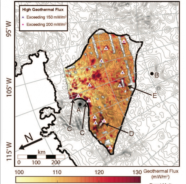
Scientists in the university’s Institute for Geophysics say they used ice-penetrating radar aboard aircraft to find significant geothermal heat sources — hotter and spread over a broader area than previously thought — underneath the glacier.

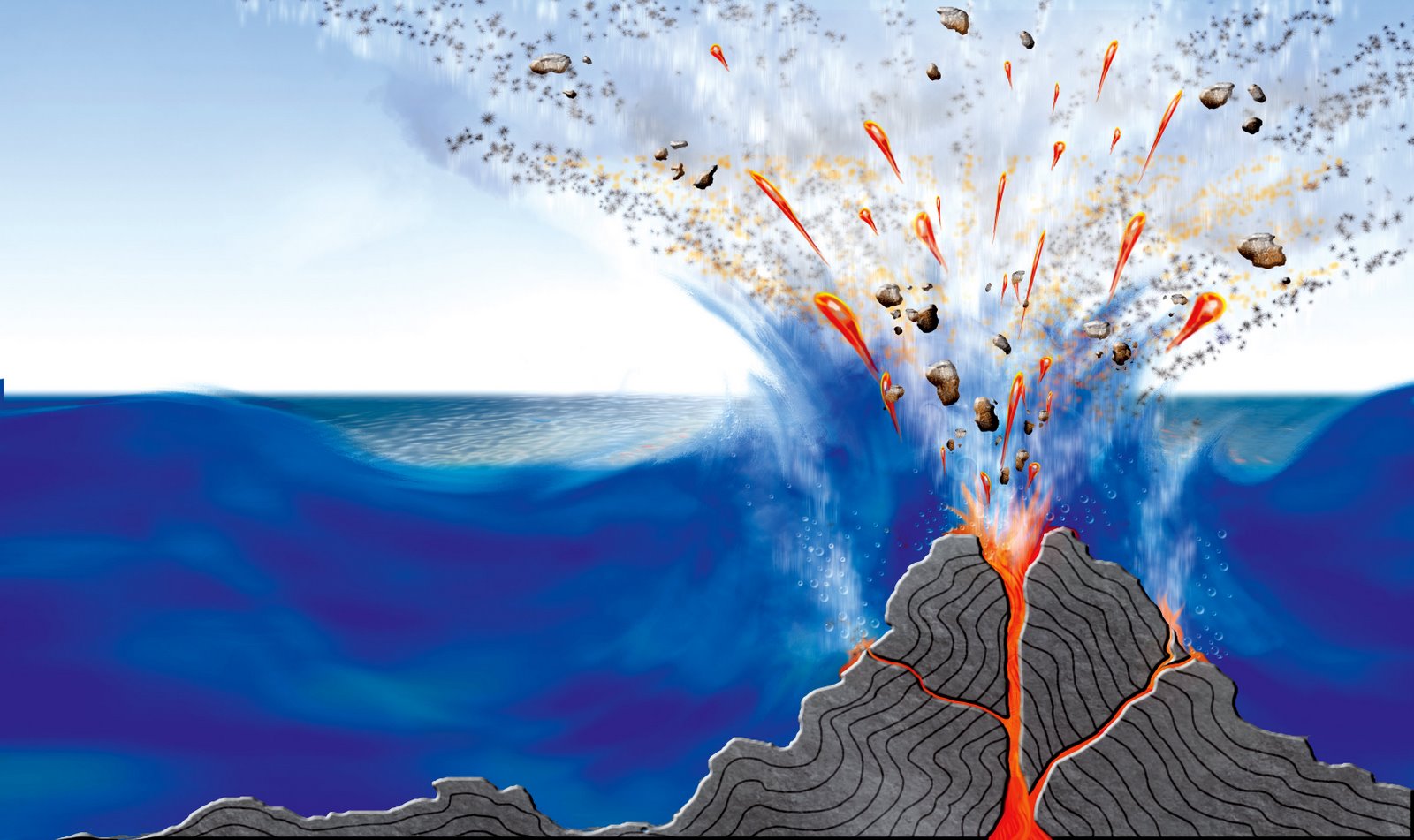
Caused by magma moving underground and volcanic activity associated with that movement, geothermal heat might represent a significant factor in changing the stability of the ice mass above, they researchers reported in the Proceedings of the National Academy of Sciences.

Rather than a uniform region of heat beneath, like a pancake griddle, geothermal sources under the Thwaites Glacier more resemble a stove top with a multitude of burners emitting heat in different locations and at different levels, research scientist Don Blankenship says.

“It’s the most complex thermal environment you might imagine,” he says. “And then you plop the most critical dynamically unstable ice sheet on planet Earth in the middle of this thing, and then you try to model it. It’s virtually impossible.”

The geothermal heat under the glacier averages around 100 milliwatts in each square meter, the researchers said, with some hotspots putting out 200 milliwatts per square meter.

Under the Earth’s other continents the average is less than 65 milliwatts per square meter, they said.

The Thwaites Glacer is an outflow glacier — pushing into the Amundsen Sea — that is the size of Florida and hold the key to trying to predict possible future rises in sea levels, they said.

Studying it could help yield clues to the future state of the entire West Antarctic Ice sheet, they added.

A complete collapse of Thwaites Glacier could push global sea levels up by three to six feet, and a melting of the entire ice sheet could double that, the researchers said.

The combination of warm ocean water and underlying geothermal heat makes the future of the glacier difficult to predict, lead study author Dusty Schroeder says.

“The combination of variable subglacial geothermal heat flow and the interacting subglacial water system could threaten the stability of Thwaites Glacier in ways that we never before imagined,” he says.

http://www.techtimes.com/articles/8268/20140610/underground-volcanoes-spur-antartic-glaciar-melt.htm

9 lousy places for a vacation

1. Buford, Wyoming
1 -  Buford
Formerly sporting a bustling population of two, Buford now only has a single resident.

2. The Great Pacific Garbage Patch
2 - garbage
The Patch is a basically immobile, gigantic mass of trash out in the middle of the Pacific. Most estimates put its size—composed entirely of plastic bottles, chemical sludge, and basically any other kind of debris you can imagine—larger than the state of Texas. You’d probably rather go to Texas.

3. Alnwick Poison Garden, England
3 - posion gardcen
The Alnwick Poison Garden is pretty much what you’d think it is: a garden full of plants that can kill you (among many other things). Some of the plants are so dangerous that they have to be kept behind bars. It’s not exactly your typical stroll through a botanical garden.

4. Ramree Island, Burma
4 - bur,a
Ramree Island may be in the beautiful Burma, but nothing about this place is beautiful. It’s actually just a giant swamp full of thousands of saltwater crocodiles—which are the deadliest in the world—plus mosquitos loaded with malaria, oh, and venomous scorpions. Also, there was a six-week long battle here during WWII, in which only twenty Japanese soliders survived… out of 1000. And most were killed by the wildlife.

5. The Zone of Alienation, Ukraine
5 - ukraine
Although you probably wouldn’t want to vacation in Pripyat either, the Zone of Alienation is the 19-mile decommissioned perimeter surrounding the grounds of the Chernobyl incident. It’s administered by a branch of government specifically so that no-one is allowed into it, but there are a few hundred residents who refused to move. What’s wrong with those people? You probably don’t want to know

6. Ilha de Queimada Grande, Brazil
6 - brazil
Sorry to tell you this, but Ilha de Queimada Grande isn’t a fantastical island getaway. It’s actually an island full of thousands of snakes. Its name literally means, “Snake Island.” It has the highest concentration of snakes in the world, with 1-5 golden lanceheads per square meter—oh, and they’re very poisonous: when designs were drawn up to build a plantation on the island, all the scouts were killed.

7. St. Helena
7 - st helena
If you somehow end up in the same place where Napoleon was imprisoned and spent his final days, things are probably going wrong. Oh yeah, and there’s no functioning airport, either. The only way you can get on or off the island is via container ships from South Africa. Which only come every few months.

8. Izu Island, Japan
8 - japan
The Izus are a group of volcanic islands located off the southern coast of Japan’s Honshu island. They’re technically part of Tokyo, except because they’re extremely volcanic, the air constantly smells of sulfur and residents have been evacuated twice—in 1953 and 2000—because of “dangerously high levels of gas.” Although allowed back in 2005, inhabitants are now required to carry gas masks on their person at all times.

9. Mud Volcanoes of Azerbaijan
9 - mud volcano
Sure, mud volcanoes aren’t nearly as dangerous as their cousins of the magmatic variety, but when they do actually erupt, it’s not exactly a pretty sight. In 2001, a new island grew out of the Caspian Sea, due to an increase in volcanic activity—right nearby where hundreds of these bad boys are. Generally, they go off every twenty years, and when they do, they shoot flames “hundreds of meters into the sky” and deposit tons of mud into the immediate area.

http://www.stumbleupon.com/su/AVvBxP

Largest volcano on Earth discovered lurking beneath Pacific Ocean and named after Texas A&M University

volcano

The world’s largest volcano lurks beneath the Pacific Ocean, researchers announced Thursday in the journal Nature Geoscience.

Called the Tamu Massif, the enormous mound dwarfs the previous record holder, Hawaii’s Mauna Loa, and is only 25 percent smaller than Olympus Mons on Mars, the biggest volcano in Earth’s solar system, said William Sager, lead study author and a geologist at the University of Houston.

“We think this is a class of volcano that hasn’t been recognized before,” Sager said. “The slopes are very shallow. If you were standing on this thing, you would have a difficult time telling which way was downhill.”

Tamu is 400 miles (650 kilometers) wide but only about 2.5 miles (4 km) tall. It erupted for a few million years during the early Cretaceous period, about 144 million years ago, and has been extinct since then, the researchers report.

Like other massive volcanoes, Tamu Massif seems to have a central cone that spewed lava down its broad, gentle slopes. The evidence comes from seismic surveys and lava samples painstakingly collected over several years of surveys by research ships. The seismic waves show lava flows dipping away from the summit of the volcano. There appears to be a series of calderas at the summit, similar in shape to the elongated and merged craters atop Mauna Loa, Sager said.

Until now, geologists thought Tamu Massif was simply part of an oceanic plateau called Shatsky Rise in the northwest Pacific Ocean. Oceanic plateaus are massive piles of lava whose origins are still a matter of active scientific debate. Some researchers think plumes of magma from deep in the mantle punch through the crust, flooding the surface with lava. Others suggest pre-existing weaknesses in the crust, such as tectonic-plate boundaries, provide passageways for magma from the mantle, the layer beneath the crust. Shatsky Rise formed atop a triple junction, where three plates pulled apart.

Tamu Massif’s new status as a single volcano could help constrain models of how oceanic plateaus form, Sager said. “For anyone who wants to explain oceanic plateaus, we have new constraints,” he told LiveScience. “They have to be able to explain this volcano forming in one spot and deliver this kind of magma supply in a short time.”

Geochemist David Peate of the University of Iowa, who was not involved in the study, said he looks forward to new models explaining the pulses of magma that built Shatsky Rise. Tamu Massif is the biggest and oldest volcano, and the cones grow smaller and younger to the northeast of Tamu. Sager and his colleagues suggest that pulses of magma created the volcanic trail.

“It seems that in many oceanic plateaus the melting is continuous, but here you have a big shield volcano,” Peate told LiveScience. “Understanding the source of the volume of that magma, the rate of production of the magma and the time interval between those pulses will help give better constraints to feed into those models,” he said.

Sager said other, bigger volcanoes could be awaiting discovery at other oceanic plateaus, such as Ontong Java Plateau, located north of the Solomon Islands in the southwest Pacific Ocean. “Structures that are under the ocean are really hard to study,” he said.

Oceanic plateaus are the biggest piles of lava on Earth. The outpourings have been linked to mass extinctions and climate change. The volume of Tamu Massif alone is about 600,000 cubic miles (2.5 million cubic km). The entire volcano is bigger than the British Isles or New Mexico.

Despite Tamu’s huge size, the ship surveys showed little evidence the volcano’s top ever poked above the sea. The world’s biggest volcano has been hidden because it sits on thin oceanic crust (or lithosphere), which can’t support its weight. Its top is about 6,500 feet (1,980 meters) below the ocean surface today.

“In the case of Shatsky Rise, it formed on virtually zero thickness lithosphere, so it’s in isostatic balance,” Sager said. “It’s basically floating all the time, so the bulk of Tamu Massif is down in the mantle. The Hawaiian volcanoes erupted onto thick lithosphere, so it’s like they have a raft to hold on to. They get up on top and push it down. And with Olympus Mons, it’s like it formed on a two-by-four.”

Sager and his colleagues have studied Shatsky Rise for decades, seeking to solve the puzzle of oceanic plateaus. About 20 years ago, they named Tamu Massif after Texas A&M University, Sager’s former employer, he said.

http://www.nbcnews.com/science/its-largest-volcano-earth-it-lurks-beneath-pacific-ocean-8C11085698

Ancient Irish texts show volcanic link to cold weather

irish volcano

By Matt McGrath

Environment correspondent, BBC News

Researchers have been able to trace the impact of volcanic eruptions on the climate over a 1200 year period by assessing ancient Irish texts.

The international team compared entries in these medieval annals with ice core data indicating volcanic eruptions.

Of 38 volcanic events, 37 were associated with directly observed cold weather extremes recorded in the chronicles.

The report is published in the journal Environmental Research Letters.

In the dim light of the Dark Ages, the Irish literary tradition stands out like a beacon.

At monastic centres across the island, scribes recorded significant events such as feast days, obituaries and descriptions of extreme cold and heat.

These chronicles are generally known as the Irish Annals and in this report, scientists and historians have looked at 40,000 entries in the texts dating from AD431 to 1649.

The researchers also looked at the Greenland Ice Sheet Project (GISP2) ice-core data.

When volcanoes erupt, they produce sulphate aerosol particles which down the centuries have been deposited on and frozen in ice sheets, leaving an extremely accurate temporal record of the event.

Scientists say these particles reflect incoming sunlight and can cause a temporary cooling of the Earth’s surface. In a country with a mild maritime climate like Ireland, these colder events would have a significant impact.

When the weather that is cold enough to allow you to walk over a lake in Ireland, it is pretty unusual,” lead author Dr Francis Ludlow, from Harvard University, told BBC News.

“When it happened, it was remarkable enough to be recorded pretty consistently.”

The scientists in the team identified 48 volcanic eruptions in the time period spanning 1,219 years. Of these, 38 were associated closely in time with extreme weather events identified in the Irish texts.

“These eruptions occur and they override existing climate patterns for a period of two or three years,” said Dr Ludlow.

“And it is clear from the sources that they cause a lot of devastation among societies at the time – whether it was the mass mortality of domestic animals or humans, or indirectly by causing harvest failure.”

The research team believe the texts are accurate as the annals also record solar and lunar eclipses which can be compared with other contemporary sources.

The keen recording of weather though had another motivation.

“A lot of these scribes are working in monasteries, in some time periods they are interpreting these weather events as divine omens or portents as signals of the coming of the last days,” said Dr Ludlow.

“That was one of their motivations so we are able to use the records that were created for a completely different purpose that the scribes would never have conceived.”

The researchers say that one expected effect of volcanic eruptions that occur in tropical regions is to make for milder winters in northern latitudes.

But in this study, they found several instances of these type of eruptions causing extremely cold winters in Ireland. The team believes their work shows the complex nature of volcanic impacts on climate, and they say there are lessons for the future in the ancient texts.

“That tells us a lot about what sort of weather we might expect in the British Isles when the next big eruption goes off,” said Dr Ludlow.

“We might want to buy a bit more salt for the roads.”

http://www.bbc.co.uk/news/science-environment-22786179

Thanks to Kebmodee for bringing this to the attention of the It’s Interesting community.

Strengthened link between climate change and volcanic eruptions established

volcano1

It has long been known that volcanic activity can cause short-term variations in climate. Now, researchers at the GEOMAR Helmholtz Centre for Ocean Research Kiel (Germany), together with colleagues from Harvard University have found evidence that the reverse process also occurs: Climate affects volcanic activity. “In times of global warming, the glaciers are melting on the continents relatively quickly. At the same time the sea level rises. The weight on the continents decreases, while the weight on the oceanic tectonic plates increases. The stress changes within in the earth to open more routes for ascending magma” says geophysicist Dr Marion Jegen from GEOMAR, who participated in the study. The rate of global cooling at the end of the warm phases is much slower, so there are less dramatic stress changes during these times.

“If you follow the natural climate cycles, we are currently at the end of a really warm phase. Therefore, things are volcanically quieter now. The impact from man-made warming is still unclear based on our current understanding” says GEOMAR volcanologist Dr Steffen Kutterolf, who has been with SFB 574 since its founding.
In 1991, it was a disaster for the villages nearby the erupting Philippine volcano Pinatubo. But the effects were felt even as far away as Europe. The volcano threw up many tons of ash and other particles into the atmosphere causing less sunlight than usual to reach the Earth’s surface. For the first few years after the eruption, global temperatures dropped by half a degree. In general, volcanic eruptions can have a strong short-term impact on climate. Conversely, the idea that climate may also affect volcanic eruptions on a global scale and over long periods of time is completely new.

Researchers at GEOMAR Helmholtz Centre for Ocean Research Kiel (Germany) and Harvard University in Massachusetts (USA) have now found strong evidence for this relationship from major volcanic eruptions around the Pacific Ocean over the past 1 million years. They have presented their results in the latest issue of the international journal Geology.

For more than ten years the project has been extensively exploring volcanoes of Central America. “Among others pieces of evidence, we have observations of ash layers in the seabed and have reconstructed the history of volcanic eruptions for the past 460,000 years,” says Kutterolf. Particular patterns started to appear. “There were periods when we found significantly more large eruptions than in others” says Kutterolf.

After comparing these patterns with the climate history, there was an amazing match. The periods of high volcanic activity followed fast, global temperature increases and associated rapid ice melting. To expand the scope of the discoveries, Dr Kutterolf and his colleagues studied other cores from the entire Pacific region. These cores had been collected as part of the International Integrated Ocean Drilling Program (IODP) and its predecessor programmes. They record more than a million years of the Earth’s history.

“In fact, we found the same pattern from these cores as in Central America” says Jegen. Together with colleagues at Harvard University, the geologists and geophysicists searched for a possible explanation. They found it with the help of geological computer models.

The next step is to investigate shorter-term historical variations to better understand implications for the present day.

For more information: Kutterolf, S., M. Jegen, J. X. Mitrovica, T. Kwasnitschka, A. Freundt, P. J. Huybers (2012): A detection of Milankovitch frequencies in global volcanic activity. Geology, G33419.1, dx.doi.org/10.1130/G33419.1 Journal reference: Geology

http://www.dailygalaxy.com/my_weblog/2012/12/ecoalert-strong-link-between-climate-change-and-volcanic-eruptions-discovered.html

300 Million Year Old Chinese Tropical Forest Discovered Buried Under Volcanic Ash


About 300 million years ago, volcanic ash buried a tropical forest located in what is now Inner Mongolia, much like it did the ancient Roman city of Pompeii.

This preserved forest has given researchers the unusual opportunity to examine an ecosystem essentially frozen in place by a natural disaster, giving them a detailed look at ancient plant communities and a glimpse at the ancient climate.

This ancient, tropical forest created peat, or moist, acidic, decaying plant matter. Over geologic time, the peat deposits were subjected to high pressure and became coal, which is found in the area.   

The volcano appears to have left a layer of ash that was originally 39 inches (100 centimeters) thick.

“This ash-fall buried and killed the plants, broke off twigs and leaves, toppled trees, and preserved the forest remains in place within the ash layer,” the authors, led by Jun Wang of the Nanjing Institute of Geology and Palaeontology in China, wrote in an article published Monday (Feb. 20) in the journal Proceedings of the National Academy of Sciences.  

The ash layer dated to about 298 million years ago, early in the Permian Period, when the supercontinent Pangea was coming together.

The researchers examined three sites with a total area of 10,764 square feet (1,000 square meters) near Wuda, China. At these sites, they counted and mapped the fossilized plants. The tallest trees that formed the upper canopy — species in the genera Sigillaria and Cordaites — grew to 82 feet (25 meters) or more. Lower down, tree ferns formed another canopy. A group of now-extinct, spore-producing trees called Noeggerathiales and palm-like cycads grew below these, they found. [Image Gallery: A Petrified Forest]

“It’s marvelously preserved,” University of Pennsylvania paleobotanist and study researcher Hermann Pfefferkorn said in a press release issued by the university. “We can stand there and find a branch with the leaves attached, and then we find the next branch and the next branch and the next branch. And then we find the stump from the same tree. That’s really exciting.”

http://www.csmonitor.com/Science/2012/0221/300-million-year-old-Chinese-Pompeii-found-buried-under-volcanic-ash


Thank to P.C. for bringing this to the attention of the It’s Interesting community.

Massive Alaskan Volcano May Erupt and Disrupt Air Travel


Officials are monitoring a remote Alaska volcano that could launch an ash cloud, potentially threatening intercontinental flights.

“Eruptive activity” of Cleveland Volcano was detected in satellite data, according to the Alaska Volcano Observatory.

The volcano, also known as Mount Cleveland, is on the Aleutian Islands, southwest of mainland Alaska.

“A new lava dome has been observed in the summit crater,” the observatory said Tuesday. “There have been no observations of ash emissions or explosive activity during this current lava eruption.”

But the volcanic activity could heighten and affect air travel, said Steve McNutt, a scientist at the University of Alaska Fairbanks.

McNutt said 90% of air freight from Asia to Europe and North America flies over Alaska air space, and hundreds of flights — including more than 20,000 passengers — fly through Anchorage’s air space daily.

“If there is an explosion and (ash) reaches high altitudes, it will causes flights to be rerouted and ultimately canceled,” McNutt said.

The volcano’s most recent significant eruption took place in 2001. It produced three explosions that led to ash clouds as high as 7.5 miles (12 kilometers) above sea level, according to the volcano observatory.

“The 2001 eruption also produced a rubbly lava flow and hot avalanche that reached the sea,” the observatory said.

Last year, volcanic ash spewing from Iceland’s Grimsvotn volcano forced the cancellation of hundreds of flights across Europe.

The Grimsvotn eruption came about 13 months after Iceland’s Eyjafjallajokull volcano belched smoke and ash into the skies, forcing the cancellation of thousands of flights per day at the peak of the problem.

http://www.cnn.com/2012/02/01/us/alaska-volcano/index.html

Chain of Giant Underwater Volcanoes Discovered Near Antarctica

All told a dozen previously unknown peaks were discovered beneath the waves—some up to 10,000 feet (3,000 meters) tall, according to the British Antarctic Survey.

The volcanoes were found near the U.K. territories of the South Georgia Islands and South Sandwich Islands.

Read about it here in Nat Geo:  http://news.nationalgeographic.com/news/2011/07/110715-undersea-volcanoes-antarctica-science-tsunamis/?source=email_gg

Inside a volcano

Volcanologists Dario Tedesco and Ken Sims descended deep into Nyiragongo, one of the most active volcanoes in the world, located in the war-torn Democratic Republic of Congo.

Tadesco and Sims hope to gather data that could help predict an eruption, which would completely devestate the surrounding area with a population of one million. 

Click here to read the full story in National Geographic: http://ngm.nationalgeographic.com/2011/04/nyiragongo-volcano/finkel-text

Click here to see stunning photographs of this volcano exploration:  http://ngm.nationalgeographic.com/2011/04/nyiragongo-volcano/peter-photography

And click here to read Nat Geo’s account of other looming threats in this region:  http://ngm.nationalgeographic.com/2011/04/nyiragongo-volcano/volcano-interactive

Thanks to Mr. C for bringing this to the attention of the It’s Interesting community.

Supervolcano

Supervolcanos produce eruptions with ejecta greater than 1,000 cubic kilometers (240 cubic miles) – thousands of times larger than most historic volcanic eruptions.  Supervolcanoes occur when magma rises into the crust from a hotspot but is unable to break through that crust until pressure builds to a phenomenally high level.  Yellowstone National Park is a supervolcano that last erupted 640,000 years ago. 

http://dsc.discovery.com/convergence/supervolcano/supervolcano.html

Some scientists are worried that we’re overdue for another eruption.  The floor of the Yellowstone supervolcano has risen 3 inches a year for the past 3 years, the fastest rate since records began in 1923. 

http://www.earthmountainview.com/yellowstone/yellowstone.htm

http://news.nationalgeographic.com/news/2011/01/110119-yellowstone-park-supervolcano-eruption-magma-science/

Here’s what National Geographic predicts will happen when Yellowstone explodes:

http://ngm.nationalgeographic.com/2009/08/yellowstone/achenbach-text